this post was submitted on 30 Nov 2024
363 points (98.1% liked)

Map Enthusiasts

5565 readers
3 users here now

For the map enthused!

Rules:

founded 2 years ago
MODERATORS
 
top 50 comments
sorted by: hot top controversial new old
[–] FlyingSquid@lemmy.world 38 points 1 year ago* (last edited 1 year ago) (4 children)

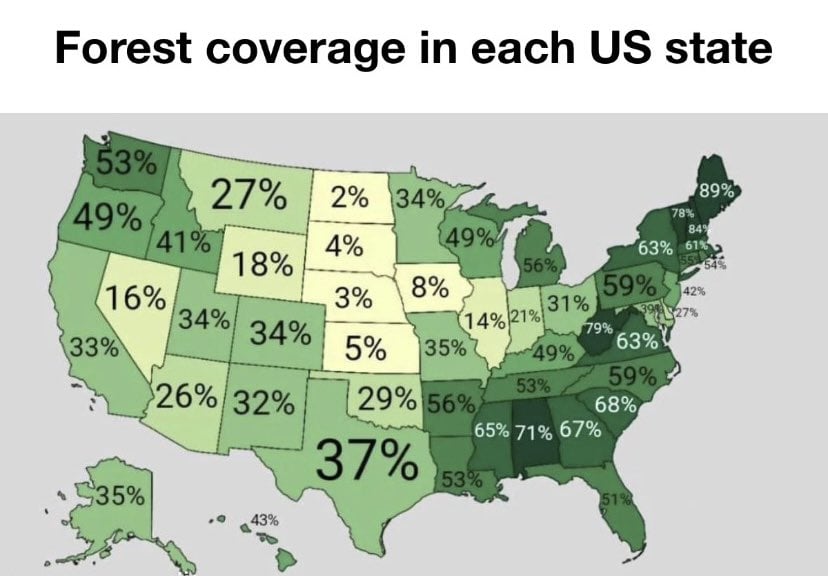
The 21% for Indiana is a little deceptive, because the northern half of the state is not very wooded at all, but the further south from Indianapolis you get, the more forested it gets. You can see it on this satellite map.

The glaciers pushed all the land in the south upward and made it very hilly, which is good tree country. As for the north, it's not because forests were clear cut. It's actually for a worse reason. The north used to be part of one of the world's biggest wetlands, the Grand Kankakee Marsh. It's been almost entirely drained for farmland.

https://www.southbendtribune.com/story/opinion/2016/01/02/andrea-neal-draining-of-kankakee-basin-destroyed-indiana-habita/46557981/

[–] iAmTheTot@sh.itjust.works 32 points 1 year ago (1 children)

What exactly is deceptive about that?

[–] FlyingSquid@lemmy.world 4 points 1 year ago (4 children)

Because it's not evenly distributed, but a good 30% of the state is heavily forested and another good 20% is forested but not heavily so. The map gives an impression (for each state really) that it is an even distribution in some way. Really, doing this in a state-by-state way as if political boundaries all made geographic sense is not very informative.

[–] captainlezbian@lemmy.world 21 points 1 year ago

I would expect most to not be evenly distributed. Florida’s forests are likely largely the Everglades, and I’d suspect New Mexico’s are up north outside the desert.

And yeah, here in Ohio the remaining forests are largely in the south, but we were once a very forested state

[–] iAmTheTot@sh.itjust.works 19 points 1 year ago

I don't why you get an impression from the original infographic that it implies even distribution. I don't get that at all.

[–] chuckleslord@lemmy.world 16 points 1 year ago (1 children)

Minnesota is heavily wooded, but only up north. It's not deceptive, it's how trees work.

[–] Monument@lemmy.sdf.org 4 points 1 year ago (1 children)

How do the trees know to stay north? They got Tree-PS or something?

[–] chuckleslord@lemmy.world 4 points 1 year ago

The south is where the forests from Canada give way to the Great Plains of the Midwest. Just a quirk of the geography.

[–] CanadaPlus@lemmy.sdf.org 7 points 1 year ago (1 children)

It's a safe bet most of these aren't evenly distributed.

[–] AngryCommieKender@lemmy.world 2 points 1 year ago

I would wager Maine is fairly evenly distributed, but that seems like a safe bet.

[–] Monument@lemmy.sdf.org 3 points 1 year ago* (last edited 1 year ago)

I guess I know the tree cover isn’t equally distributed, but it’s not necessarily my first thought, either. Pretty human mistake.

Thanks for the interesting and informative comment. I had no idea Indiana was like that. However, I did know that Ohio is similar because I’ve done research on Hocking Hills, and one of the things I read also talked about the park being outside the range of glacial erosion and how, in general, the more southerly areas represent ancient geology.

Hocking Hills is a lovely, if heavily visited, state park in Ohio.

[–] Liz@midwest.social 2 points 1 year ago* (last edited 1 year ago)

Who we calling deceptive? The GKM was big, but it wasn't "no forests in northern Indiana" big.

https://en.wikipedia.org/wiki/Topical_steroid_withdrawal?wprov=sfla1

[–] njm1314@lemmy.world 1 points 1 year ago (1 children)

It's always weird how people get preconceived notions of what a chart graph or map should be implying and then get frustrated when those preconceptions aren't met because that's not the point of said map graph or chart. I mean nothing in that map implied it was spread all over the state and yet you're angry about it for no freaking reason. And it's such a weird preconception too, I mean who honestly thinks that Landscapes are spread evenly over an area? Anyone who went through Elementary School knows that's not true.

[–] FlyingSquid@lemmy.world 2 points 1 year ago

I'm not frustrated.

[–] actually@lemmy.world 36 points 1 year ago (1 children)

Texas is nothing but trees in the east, and no trees in the west.

But none of it are the original ecosystems: all the trees in the east were cut down and now it’s more or less a mono-culture of pines, with many invasive species; the plains were destroyed with a few holdouts; and I have no clue about in the west but I suspect that was messed up too.

But even 150 years ago a lot of forests in the east were still multistory with different layers of canopy. If left alone, someone said it would takes thousand of years for them to grow back to that.

Right now it’s just dense small pines cut down every few years, all over the state, and hard to walk though. Much easier to travel through earlier.

I live in the east where there was fifteen thousand years of history here, and a few thousand years of villages and larger settlements and several languages. But most those are forgotten because of the genocide which ended in my great great grandfather’s time.

But even earlier a previous ecosystem was destroyed by hunting out the large animals, which fundamentally changed the look of area. Trees just grow differently when there are large herbivores. There were more open areas in the forests too.

And in another hundred years most of these pine forests will be gone too, thanks to global warming. Probably too dry and hot that will blow off the top soil, causing rapid desertification . And the current people will move , most of them, and once again the land will forget its nature and people, towns will be forgotten.

[–] 3ntranced@lemmy.world 4 points 1 year ago

The Woodlands, TX resident. Can confirm, many trees over here. Further east and it's just trees, the ents are migrating.

[–] Swedneck@discuss.tchncs.de 21 points 1 year ago (6 children)

i genuinely cannot imagine such a large piece of land being 2% forest, i would lose my mind travelling through that

[–] pixelscript@lemm.ee 11 points 1 year ago (4 children)

It's even stranger than that.

There are a fair few trees here. But most of them aren't natural, they were planted. Planted in perfectly straight, compass-axis lines that run for about a kilometer each, slicing the plain into a giant square checker pattern.

load more comments (4 replies)
[–] odium@programming.dev 10 points 1 year ago* (last edited 1 year ago) (1 children)

picture a 60 mph / 100 kmph road with one lane on each side winding between endless hills covered with medium height yellow grass and dotted with the occasional grazing cow, elk, etc.

That's what most of the state looks like in my experience. Pretty beautiful.

[–] Swedneck@discuss.tchncs.de 4 points 1 year ago (1 children)

sure it's beautiful, the ocean is beautiful too, but that much open space would make me so uncomfortable. Denmark is bad enough.

[–] Zorsith@lemmy.blahaj.zone 2 points 1 year ago

The ground isn't even the unnerving part; it's how much of your vision is taken up by empty sky. It makes you feel absolutely miniscule

[–] bdonvr@thelemmy.club 6 points 1 year ago

It's got it's own beauty in a way. Soft rolling hills and an endless horizon.

[–] captainlezbian@lemmy.world 6 points 1 year ago (1 children)

My family drove through Kansas once when I was a kid, and yep, the Great Plains are kinda rough on the head if you aren’t used to open grasslands. It’s like being on the ocean but grassland instead of water. Just grass and land as far as the eye can see

[–] Zorsith@lemmy.blahaj.zone 1 points 1 year ago

The Flint Hills are beautiful

[–] mitchty@lemmy.sdf.org 2 points 1 year ago

I grew up there, it’s a tundra/prairie biome. I grew up in the he’ll creek formation area though so lots of buttes. Any trees were largely planted by settlers.

It’s quite beautiful in its own right. Just avoid the eastern part of the state, that bits flat as a board and about as boring.

[–] StereoCode@lemmy.world 14 points 1 year ago* (last edited 1 year ago)

Maine represent! That's right only about a million people live here.

[–] CanadaPlus@lemmy.sdf.org 14 points 1 year ago (1 children)

Mississippi, Jesus.

The black belt is such a massively underrepresented area in media I guess I shouldn't be surprised I had no idea it was forested.

[–] Liz@midwest.social 20 points 1 year ago (1 children)

The only reason Illinois, Indiana, and Ohio are so low is because of the massive farms. They were originally all forest.

[–] CanadaPlus@lemmy.sdf.org 6 points 1 year ago* (last edited 1 year ago) (1 children)

It must be that everything east of the Great Plains was originally, in America. In Canada the boreal forest stretches coast to coast (and hasn't gotten much smaller to date).

[–] gens@programming.dev 2 points 1 year ago (1 children)

There weren't many meadows before humans came, it was all forrest.

[–] Liz@midwest.social 2 points 1 year ago

Not in the East, anyway. The Great plains have always been massive grasslands.

[–] captainlezbian@lemmy.world 13 points 1 year ago (2 children)

Did not expect Alabama to be on the same level as West Virginia and Vermont

[–] BetaBlake@lemmy.world 11 points 1 year ago

Alabamian here, it's nothing but trees here, I haven't seen open land in years

[–] MutilationWave@lemmy.world 7 points 1 year ago

The forests are one of the few things left to love about my godforsaken state (WV).

[–] superduperpirate@lemmy.world 13 points 1 year ago (2 children)

I’m surprised Nevada is that high

[–] dditty@lemm.ee 15 points 1 year ago

Apparently the Humboldt Toiyabe National Forest in Nevada is the largest U.S. National Forest reservation outside of Alaska

[–] bdonvr@thelemmy.club 8 points 1 year ago (1 children)

Not quite the forest most people picture

[–] Iheartcheese@lemmy.world 7 points 1 year ago

Forest of SECRET UFO BASES

[–] CptInsane0@lemmy.world 11 points 1 year ago

Alabama: "for now. We'll show that nature what's what."

[–] FourPacketsOfPeanuts@lemmy.world 10 points 1 year ago* (last edited 1 year ago)

Alabama accent: grow forest, grow!

[–] aeronmelon@lemmy.world 8 points 1 year ago (1 children)

That’s… why it’s called the Great Plains.

[–] III@lemmy.world 5 points 1 year ago

Nebraska is fucking up their Arbor Day

[–] GBU_28@lemm.ee 4 points 1 year ago

Would be more informative if it was grouped by the dominant forest type. Different types have a different distribution and density

[–] nl4real@lemmy.world 3 points 1 year ago

Pleasantly surprised my state (WV) is 3rd.

I thought Missouri had more forest than that

load more comments
view more: next ›