Map Enthusiasts
4092 readers
221 users here now
For the map enthused!
Rules:
-
post relevant content: interesting, informative, and/or pretty maps
-
be nice
founded 2 years ago
MODERATORS
1
2
3
4
124
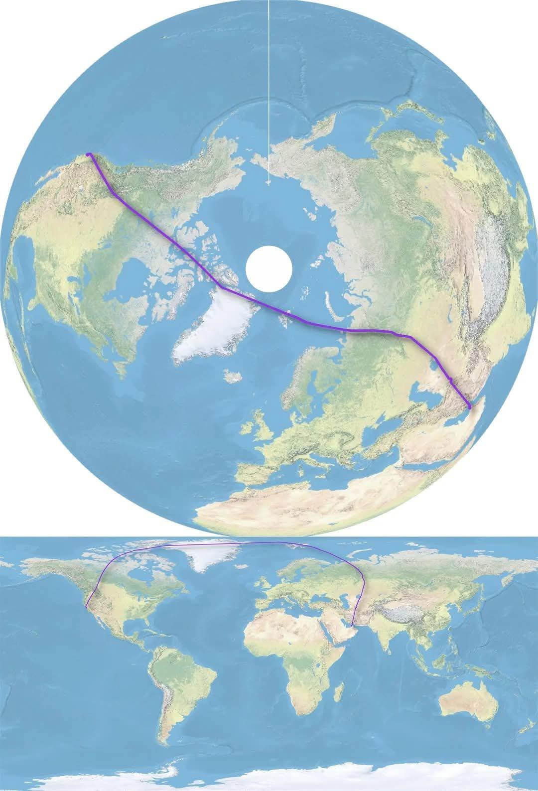
Starting from the center of Ascension Island, which countries' coastlines can you reach in a straight line?
(sopuli.xyz)

 I made this in 2022 in QGIS (but when I uploaded it on Reddit back then, you may find it as starting at Ste-Helena island.... don't ask me why, I don't remember how I made that mistake when posting it)
6

Full size here : https://www.mta.info/map/5256
Old map here https://www.nycurbanism.com/map-store/1972-vignelli-subway-map
The new map was designed by the MTA’s Creative Services Mapping Department and, like many major subway systems around the world, utilizes a diagrammatic style, employing bold, straight lines making it much easier for the eye to follow and more suitable for digital users. The white background, bold colors, horizontal writing and use of black dots make the map more ADA-friendly and easier for people with low-vision or cognitive disabilities to read.
Designers also focused on text legibility, keeping text on one line wherever possible and making better use of open space to alleviate crowding and using a black subway bullet with a white character to provide maximum contrast for easier reading. The legend on the map is now more detailed and includes accessibility, transfer, and safety information, as well as a QR code that leads users to the MTA website.
Although this map is a new design, the creative team drew inspiration from previous maps including:
- Preserving the official brand colors established by the 1979 and 1998 Hertz maps
- Using a similar geometric and diagrammatic aesthetic introduced to the New York City Subway with the 1972 Vignelli diagram and revived by its successors, Waterhouse Cifuentes


9


11

13
73
Days per year above 75°F / 24°C in the US & Canada (OP Source: Brian Brettschneider @Climatologist49)
(lemmy.world)

14
15
source: https://decolonialatlas.wordpress.com/2017/04/18/colorful-river-basin-maps/
It has more detailed maps for each continent too.


19
Wyandotte County is home of Kansas City, KS (part of the Kansas City metro area). The local community college put out this information. Both pages can be found here.

20

21
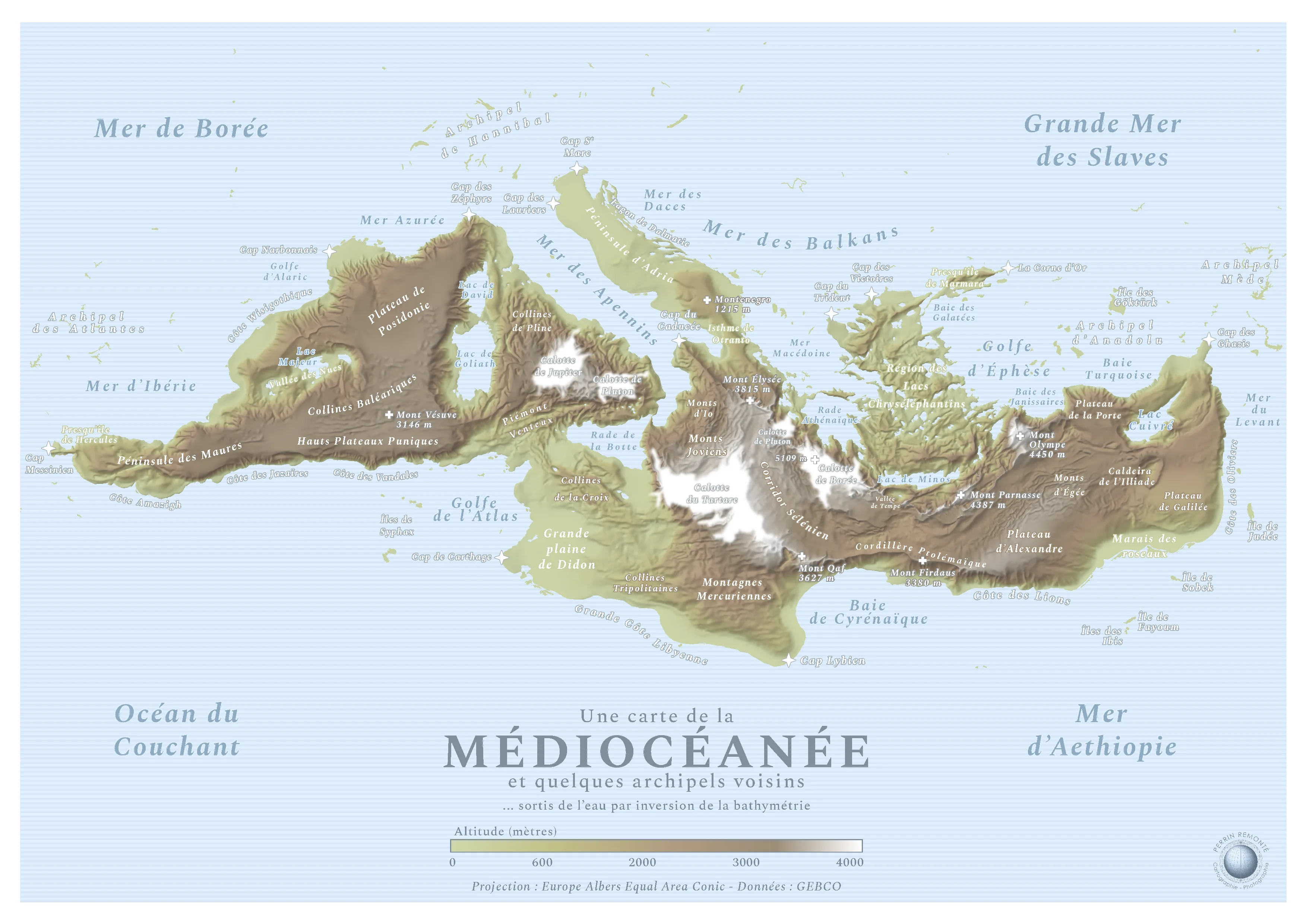
This is a map made by French cartograph Perrin Remonté:
Funny Sunday map interlude with a special map: it shows an imaginary continent hidden in the hollow of the Mediterranean, a name meaning “[the sea] in the middle of the lands”. This hidden continent is naturally “the land in the middle of the seas”, the Mediocean! The lands become seas and vice versa.
The black, inhospitable, cold and dark abysses become all white, covered with ice caps and beaten by high-altitude blizzards, like the Tartarus or Boreas caps which exceed 5000 meters in altitude, formerly 5000 meters deep while Mount Parnassus, Mount Olympus, Mount Qaf - real and legendary mountains - culminate at several thousand meters above sea level and still inspire beliefs and respect in these humans who look at them, fear them and admire them from the plains.
Sobek, Minos, Alexander, Alaric, Hannibal: the Gods, Kings and Queens rushed to give their names to these mountains, plateaus, seas, hills and coasts that emerged from the earth! It must be said that the Mediterranean is full of myths and legends, empires made and unmade, marvels of architecture or literature: the Caldera of the Iliad, the Peninsula of Hercules and the Bay of Galatea will be able to testify to this.
The map simply uses bathymetric data that I reversed, the rest is the result of intense internet research to find the best names. I am not Mediterranean for a penny, I have seen this sea once in my life but I tried to do it justice as best I could, it is a sacred piece of history and geography!
22


view more: next ›