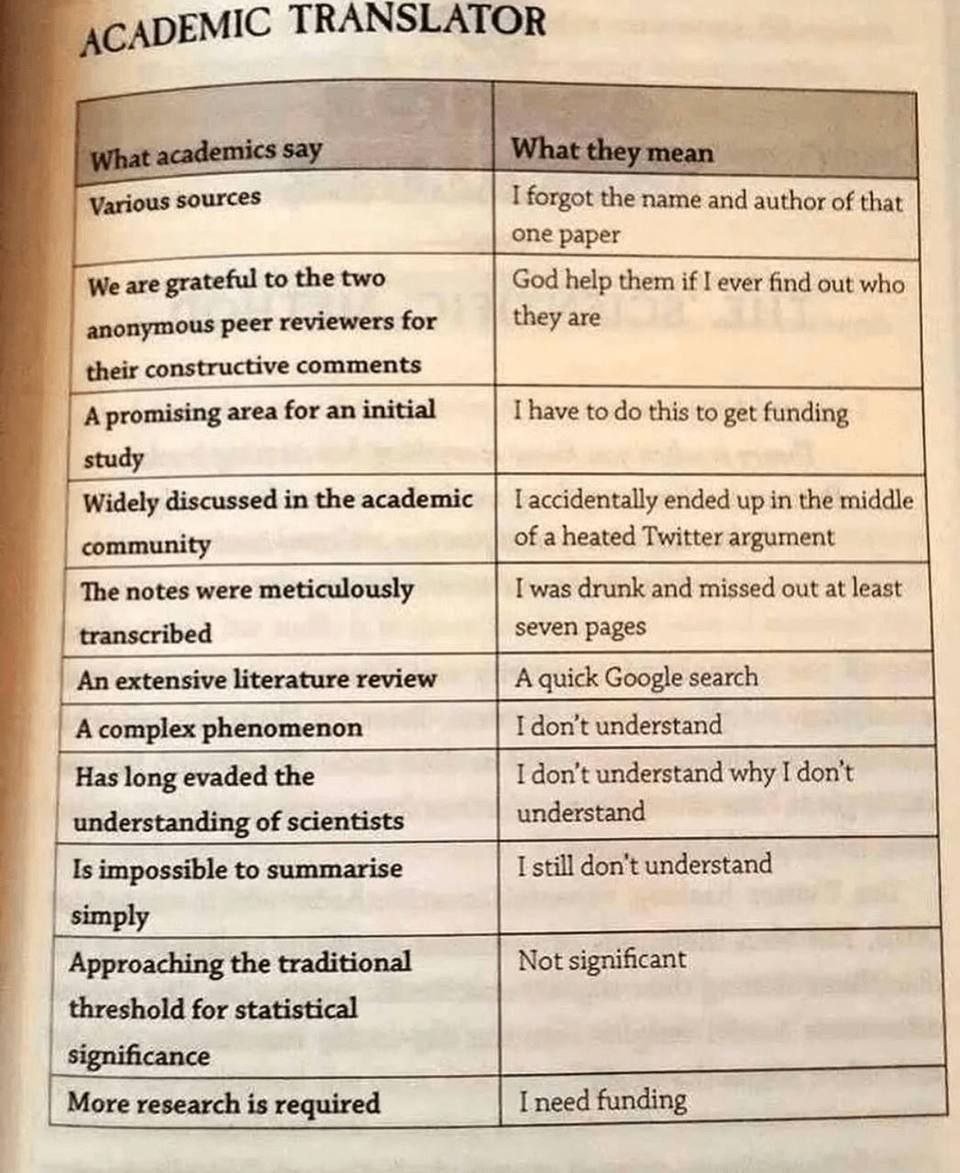
Deme

joined 2 years ago
MODERATOR OF
[–] [email protected] 2 points 1 month ago* (last edited 1 month ago)

An extreme value is always only extreme in relation to some baseline. For temperatures it's usually a value that departs far from the local average. With WBT it can also mean values that approach the limit of what the human physiology can handle, a value that is quite universal due to us all being of the same species. The body cannot adapt beyond the limits set by thermodynamics.

Tropical and extreme aren't mutually exclusive. +30°C in Antarctica would be both tropical and extreme. Both are used where applicable. A temperature can also be extreme without being tropical. No matter what Trump thinks, he doesn't have the power to redefine (let alone erase) words.

The wet bulb temp. in a proper sauna should get quite high, I don't have exact numbers but above 70°C or so (dry temp. 90°C, relative humidity 50% would translate to a WBT of 74°C). In most contexts that would be extreme, but not here.

[–] [email protected] 3 points 1 month ago* (last edited 1 month ago) (2 children)

*Extreme WBT's

A wet bulb thermometer measures wet bulb temperature (WBT), which is a metric that always exists and can always be measured. It only gets bad when the WBT reaches an extreme value, as is the case for basically all environmental metrics. Saying that wet bulb temperature is lethal is like saying that temperature is lethal. Look out for temperature! I'm sorry for the rant so I'll try to keep this short, but "wet bulb" by itself in this context is an inane shorthand that lacks all the significant words and muddles the meaning of those words that are in it. Scientists talk about Extreme WBT events, because that's what they are. A less of a mouthful would be nice for science communication, but I don't want it to come at the expense of words losing meaning like that.

Heatwave is a nice and descriptive word for one type of an extreme temperature event. Cold snap is another one. I'm glad neither is called "temperature event" because that would be dumb.

[–] [email protected] 7 points 2 months ago (1 children)

Nice! Altocumulus stratiformis undulatus, but with two intersecting systems of undulations. Think of them like cross waves at sea.

 
[–] [email protected] 1 points 3 months ago

Oh, right. I figured that a person using a screen reader can probably see that one by themselves, but I suppose I could throw that one into the post body as well.

[–] [email protected] 1 points 3 months ago

I had to do a double take when I first saw that "RASH" in the comment above. Is there a place where it's written like that instead of just SHRA or was that just a joke? Generally the pattern is always [intensity][descriptive attribute][phenomena], but the US system has so many deviations from the international standards that I can't be certain.

[–] [email protected] 1 points 3 months ago (2 children)

Thanks for the reminder!

14
submitted 3 months ago* (last edited 3 months ago) by [email protected] to c/[email protected]
 

Alt text for the comic embedded in the link: An XKCD comic about how to decode a METAR:

METAR - "Meter" (Usually misspelled)

KNYC - Station ID

251600Z - Time (25:16:002)

18035G45KT - Wind speed has been 18,035 knots for a good 45 minutes now.

6SM - Observer is a size 6 small.

VCFCFZVA - Sorry, the station cat walked on the keyboard.

+BLUP - Weird noise the sky made earlier.

NOSIG - The observer has no significant other :(

LTG OHD - We overheard someone saying there was lightning.

A3808 - Hey look, an Airbus A380-800!

RMK - Remarkable!

A02 - Fanfic archive equipped with a precipitation sensor.

SLP130= - Observer got sleepy around 1:30.

30
submitted 3 months ago* (last edited 3 months ago) by [email protected] to c/[email protected]
 

Transcript for the comic embedded in the link: An XKCD comic about how to decode a METAR:

METAR - "Meter" (Usually misspelled)

KNYC - Station ID

251600Z - Time (25:16:002)

18035G45KT - Wind speed has been 18,035 knots for a good 45 minutes now.

6SM - Observer is a size 6 small.

VCFCFZVA - Sorry, the station cat walked on the keyboard.

+BLUP - Weird noise the sky made earlier.

NOSIG - The observer has no significant other :(

LTG OHD - We overheard someone saying there was lightning.

A3808 - Hey look, an Airbus A380-800!

RMK - Remarkable!

A02 - Fanfic archive equipped with a precipitation sensor.

SLP130= - Observer got sleepy around 1:30.

Image alt-text on the website: "In the aviation world, they don't use AM/PM times. Instead, all times are assumed to be AM unless they're labeled NOTAM."

[–] [email protected] 1 points 7 months ago

Thanks! Time really is the most important ingredient. Look at enough sunsets and sunrises with an adequate camera on hand, and every now and then a great scene will come up. After that it's just point and shoot.


3
submitted 11 months ago* (last edited 11 months ago) by [email protected] to c/[email protected]
 

Cirrus and Cirrostratus progressively invading the sky are a telltale sign of an approaching warm front. In this case it was an occluded front that was rolling in. It snowed that night.

3
Snow shower [OC] (lemmy.world)
submitted 11 months ago* (last edited 11 months ago) by [email protected] to c/[email protected]
 

Don't be decieved by the anvil like shape, heavy looking precipitation and icy look of this cloud! This is far from the size and power of an actual Cumulonimbus. But it is interesting in that it fits every criteria of a Cumulonimbus capillatus incus, except the bit about considerable vertical extent for the genus. I'm quite sure that this guy didn't raise its head much above 2 km AGL.

I suppose it could be classified as a Cumulus of some sort, but it really doesn't fit well under any genus. Our systems of classification are just something that we made up. Clouds are under no obligation to conform to them. The same is true for everything else in the universe as well.


Picture taken in August 2022. Fluctus, also known as Kelvin-Helmholtz wave clouds, form when wind shear causes instability in the (usually the upper) surface of a cloud. The formation is short lived and relatively rare. It can also only be seen well from the side like here. This video contains a good explanation of the physics involved here.

 
1
submitted 1 year ago* (last edited 1 year ago) by [email protected] to c/[email protected]


Picture taken at 01:30 on 5.7.2023 at EFHK.

view more: next ›