everydayhiker

joined 1 month ago
 

Nature walk, 3.2 mi loop 406 ft Hiked 6/5/25

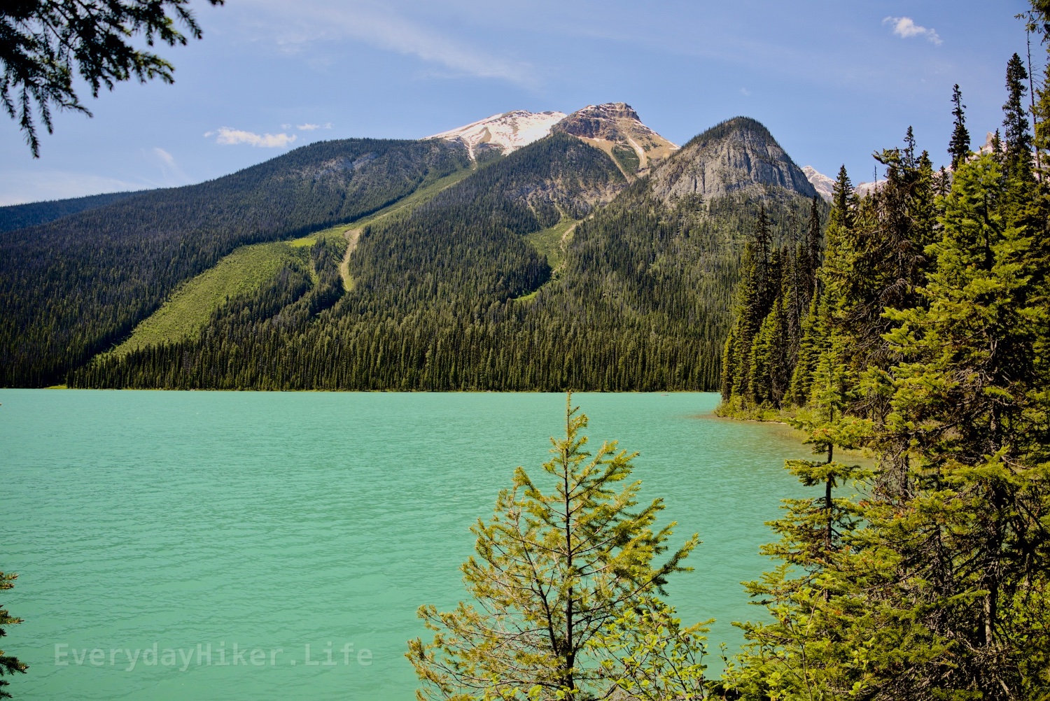
An extremely popular lake in Yoho National Park, this nature walk can be done as a full loop or shortened to near nothing and still be enjoyable. Named for its vibrant color, Emerald lake is surrounded on all sides by stunning views of the local mountains, and serves as an access to several great larger hikes such as Yoho Pass/Yoho Lake.

Looking south across Emerald lake towards Mount Burgess which is reflected in the rippled water.

The view from the south side of Emerald lake showing the avalanche zone of Emerald peak, which was still closed due to avalanche risk at the time.

Looking north from Emerald lake shows the vast avalanche field and flood plains that feeds the lake. Carmar peak, Mt Marpole, and the ridge leading up to the President sit in the background.


Moderate 8.6 mi out and back 2,192 ft elevation gain Hiked 6/4/25

An easy hike to a beautiful lake combined with a steep hike to the fabulous views from Paget Lookout. The trail splits at about halfway to each so could be isolated. Lookout trail is steep but well maintained and a scramble to Paget Peak could be added, ranger said it was a week or two from being ready, but I did see one group continue on at the time. Amazing views of Cathedral mountain as well as Divide mountain and Mt Whyte and the surrounding area.

A Trail view cutting across the steep slope of Paget mountain that shows the Cathedral mountains to the right. This is the only level section of the Lookout section and it is short lived.

The rear side of the lake has one section that passes through a washout. Trail may be seen wrapping around the beautiful lakeside with Cathedral mountain off in the distance.

Looking across the stunning waters of Sherbrooke lake towards the avalanche zone of Mt Ogden, currently a waterslide.


It has been an absolute pleasure and honor to be able to spend the last three months up here! Truly wonderful country.


Moderate 3.8 mi out and back 1,332 ft elevation gain Hiked 6/3/25

Beginning at the former Yoho NP campground, this short but steep trail takes you to one of the many great hoodoos found along the Canadian Rockies. As the trail crosses multiple washout areas, the trail degrades in places but remains manageable. A split towards the end takes you to different views which are both pretty cool, but both washed out a lot/steep.

The view up at the hoodoos from the lower trail terminus. Trees grow in the more stable sections of the hill.

An upstream view of Hoodoo creek taken from the walking bridge. Mountains may be seen in the distance.

This section of the lower hoodoos trail was very degraded, with atleast one foothold wedged into the slide.


Easy to moderate 7 mi out and back or short walk to falls only 1,496 ft elevation gain Hiked 6/1/25

Located in the Thompson Falls recreation area not too far from Golden BC this is a great waterfall with an ok trail that could be shortened to maybe half a mile or so of a mild slope. Falls were way overfull at time of hike, but appear to be a worthwhile stop, perhaps while camping in the area.

Another view of Thompson falls from a little further away, which better shows the shelf under the rushing river.

The uppermost section of falls along the trail, looks like it would have been a small cascade on the far side with a rapid on the near. Currently very blown out, the downed trees on the farside are stuck.

A jumble of fallen trees suspended in the forest. (Marge voice: I just think they're neat!)

Bluesky link to post with Videos of the falls


Easy, 2.9 mi out and back 407 ft elevation gain Hiked 6/2/25

A massive waterfall awaits you at the end of this short hike with minimal effort to access. You’ll reach the falls at the upper stage and there is a short but steep drop from there with a middle viewpoint as well as a large creekside vantage from downstream a bit.

Wapta falls from the middle viewpoint shot at 1/3s. Chancellor peak/Aquila mountain in the distance.

Wapta Falls from the middle viewpoint shot at 1/320s.

The upper view of Wapta falls, showing that weird mound that’s built up just downstream.

Link to Bluesky post with short video

[–] everydayhiker@lemmy.world 2 points 5 days ago

Thanks! Yeah it has been truly special.

[–] everydayhiker@lemmy.world 2 points 5 days ago

Yeah, the way the mist softens the details on that rock makes them almost look like cutouts or something that has that sharp edge to it.


Easy, short but steep 1 mile out and back 312 ft elevation Gain Hiked 5/27/25

This short trail begins with a very steep grade down to Connaught creek (formerly bear creek) with a stair section at the lowest. Photos of the falls come from this area downstream. Climbing another staircase puts you at the falls, surrounded by a massive mist cloud. Entertaining, but no pics. This was still during melt season and it was absolutely raging at the time.

Connaught creek rushes by as Bear creek falls rages in the distance.

The steep stairwell leading to the river below.

The steepest part of the trail is these steps, but it maintains a lot of slope in its short run.


Easy 3.2 mi out and back/loop or easier 0.8 mi hike starting at Illecillewaet campground 436 ft elevation gain Hiked 5/27/25

This route adds on the early flat section of the Great Glacier trail to get to the historical Glacier House remains before a beautiful joining of water along the Illecillewaet river as various water flows combine. Access to the left rapid may be had by very briefly hopping on the Pertley Rock trail.

The bridge spanning Illecillewaet river after Asulkan brook joins it.

Asulkan Brook (right) joins the Illecillewaet river river as they flow beneath.

Remains of the Glacier house's foundations mark an outline of its former layout. Information may be found along the trail.

[–] everydayhiker@lemmy.world 2 points 1 week ago (1 children)

If you mean Glacier on the US side, yeah my favorite park that I’ve been to. I’ll spend a little time there when I cross over, gotta get in another go on the Pitamakan-Dawson for one thing. I’ve always been there end of season though so it’ll be nice to see this time of year. Waterton will be first time for me.

[–] everydayhiker@lemmy.world 2 points 1 week ago (3 children)

Thanks! Yeah, I think Stanley glacier may be my favorite hike up here so far, but they’ve all been so nice. There is a ton I’ll need to come back and do since I came through here so early, but I am more than happy to come back. I’ve got maybe 10 more days to check out castle park and waterton area before I cross back into the states for a little while heading east. There’s still a ton of daily hikes to post before then though, I’m just going through in the order they happened.


Length: 0.5 mi loop Elevation gain: 115 ft Hike date: 5/27/25

This quick nature walk would serve as a great spot to have a picnic or to quickly stretch your legs. It still manages to provide a few different view types, including a great view of Bonney glacier to the south as well as a small boulder field and a lush forest that is taking over the rocks.

The trail through the boulders has been laid out using rocks from the boulder field making an easy path.

Pine forest and moss slowly overtakes the rock field.


Easy 1.5 mile Loop 300 ft elevation gain Hiked May 23, 2025

An extremely popular hike due to its ease and location north of Lake Louise on the Icefields Parkway, this hike puts you right on top of the falls where you may wander along the top of the canyon and see the various water chutes. A short loop uses part of the Mt Sarbach trail to get a higher view. Both parking and the people can be a mess here, so plan accordingly.

Where the river meets the canyon creating a short but turbocharged waterfall.

Mistaya canyon unfolds towards Mount Sarbach in the distance.

Mount Sarbach in the distance with Mistaya river and a forest extending downstream.

[–] everydayhiker@lemmy.world 2 points 1 week ago

Damn, that is wild. Agree on the cats, they worry more than anything and I’ve rarely ever even seen any. I had wondered if many people went out that way as a backpacking trip, but I’d say you filled it in really well. Thanks!

[–] everydayhiker@lemmy.world 1 points 1 week ago

Apparently I don’t know the right string to ping you on the other thread, but its up now. I think the final waterfall/rapid is the one you referred to, at the boundary area of the wilderness.

[–] everydayhiker@lemmy.world 1 points 1 week ago* (last edited 1 week ago) (2 children)

u/ikidd I believe the final waterfall pictured is the one you mentioned as having the campground. Its right by the boundary of the wilderness area. Definitely not the same as what I originally thought.


Moderate, 1,322 ft gain 9.5 mi Out and Back

Extending beyond Siffleur falls for another 2.3 mi to the edge of the Siffleur Wilderness area, this trail add-on increases the difficulty and the trail degrades as you get closer to the wilderness area. More views of the various rapids and falls as well as a closer look at Elbe Peak. Rope section at the end to climb a degraded hill, but not too difficult. I believe another tenth of a mile from where I turned around is a small campsite as mentioned in yesterday’s comments.

Elbe peak stabs its way upward while the Siffleur river flows through the canyon below.

The steep ridgeline of Elbe peak.

One of the better waterfalls beyond the main Siffleur falls, this is at the edge of the wilderness area and has another rapid out of frame below.

[–] everydayhiker@lemmy.world 1 points 1 week ago* (last edited 1 week ago) (3 children)

Yeah, I continued on to just past the hill with the ropes to get up and then turned around after seeing that viewpoint of the long rapid/falls. Seems like it gets pretty wild from there on. Tomorrow I’ll post a group of photos from that section beyond the main falls. Although I couldn’t get a photo I like, I think my favorite section was half a mile or less beyond the main falls where that huge wedge rock is getting cut by the river before you start to climb again. I believe that is where the camping may also be. IIRC one of the falls I’ll post tomorrow is just upstream of it. That and the bridge, I love pedestrian bridges haha.


4.4 miles roundtrip (to falls only) Easy, 475 ft elevation gain

This trail starts by crossing the N Saskatchewan river over a large pedestrian bridge. From there you will continue upstream from where the Siffleur river ends up to the main waterfall area, passing through an expansive grassland and above the canyon carved by the river. Trail may be extended well beyond the falls, I turned it into a 9.4 mile total, which I’ll post some pics for tomorrow. This trail probably doesn’t need splitting, but I’m gonna do it anyways haha.

Siffleur falls roars its way down into the canyon.

A fraction of the overall falls can be seen from this upper viewpoint. The majority is diverted behind the rock in frame.

Looking along the deep trench walls at the end of the canyon as the Siffleur river continues on.

[–] everydayhiker@lemmy.world 1 points 1 week ago

Thanks, I appreciate it! Yeah, since it’s mostly all trail photos that I take, I enjoy placing people at a distance for scale if I’m trying to include the route. Today’s post has a pretty good one as well that I liked.

[–] everydayhiker@lemmy.world 4 points 2 weeks ago

That sounds like a good adaptation they’re making, even just greater cell phone access is probably making that worse as well. I've definitely had park people scoff at me when bringing up AllTrails in the past, which is usually when I scratch that one off the list of to do’s. AllTrails also shouldn’t be encouraging shortcuts when switchbacks are there for a reason.

I’m sure this is preaching to the choir, but preparation beforehand goes so far too. It never ceases to amaze me how unprepared people are willing to go without even a set idea of where they want to be. I remember one time being at the high point of the High Divide trail in Olympic NP, WA and out of nowhere this panicked kid comes up to me asking for directions. This trail is 19 miles and 5k ft as a dayhike (people usually overnight or two) and he had just pushed on with some girl that was waiting down below a bit. This was at the halfway point so either way would’ve been fine, but he basically bailed before I could adequately explain anything. There’s a short loop of maybe 6 miles that I’m sure was what he meant to do, but how do you go ten miles on a six mile loop without turning around?

[–] everydayhiker@lemmy.world 2 points 2 weeks ago* (last edited 2 weeks ago)

Yeah, I’ve already been lukewarm on how they go about their trail data, as stressed by park rangers and this article, but overall that app has been a huge benefit for me. To me, this is likely the one step too far. One year to ween myself off of it before the subscription lapses.

[–] everydayhiker@lemmy.world 7 points 2 weeks ago

The card says ‘moops’.. fixed, thanks

view more: next ›